- The period from March to May was very warm due to the behavior of the minimum temperatures
- The quarter was the second wettest in the last 65 years
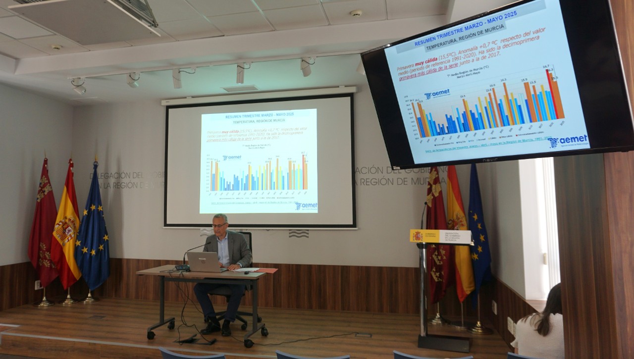
June 17, 2025. On June 21, the summer begins after a spring that, with an average temperature of 15.5°C, and an average total precipitation of 234.8 liters per square meter (l/m2), has been very warm and extremely humid, explained Juan Esteban Palenzuela, Territorial Delegate of AEMET.
According to the head of the state agency, the average of the maximum temperatures in this period was 21.0°C, with an anomaly of +0.1°C, and the average of the minimum was 9.9°C, with an anomaly of +1.1°C, being the second highest in the series, only after 2006, with 10.5°C and 1.7°C of anomaly.On average, the warmest day of the quarter was May 31, and the coldest was March 1.
In the evolution of the temperatures the following warm episodes can be highlighted:
-From 31 March to 9 April, which lasted until 14 April for the minimum; from 23 April to 7 May; from 17 to 22 May and from 25 to 31 May.
“The cold episodes were less persistent than the warm ones, and even in some cases different behaviors were observed in the evolution of the maxims and the minims, as happened for much of the first half of March, when the maxims were below their normal values and the minims well above the normal, as a result of the situation of instability that allowed the presence of cloudiness and rainfall,” Palenzuela detailed.
The highest regional daily average of the maximum temperatures was observed on May 30 and 31, with the absolute maximum temperature of the quarter being 39.0°C, on May 31 at the Mayés Reservoir Station, in Ojós. The average of the lowest maximum temperatures was observed on March 1 and 2, with the lowest maximum of the quarter recorded on March 1, 4.4°C, in Inazares, Moratalla.
The highest regional daily average of the minimum temperatures was recorded on May 31 and the highest minimum of the quarter was observed in Cartagena, at 21.1°C, this day. The lowest mean minimum temperature was observed on March 16. The minimum quarterly temperature -1.2°C, was reached on March 9 and 16 in Inazares. In addition, there have been 4 days of frost at some point in the Region, on 9, 16, 30 and 31 March and two tropical nights, on 30 and 31 May, affecting mainly the coastal resorts.
At the Murcia Observatory (1984-2025), the average of the minimum temperatures of the quarter, 12.8°C has exceeded the previous period by 0.2°C, recorded in the spring of 2006.
Precipitation
The average total rainfall in the Region of Murcia between March and May 2025 was 234.8 l/m2, which was 247% of the average value of the reference period, this period being extremely humid. It was the second wettest spring quarter of at least the last 65 years, after 2022, with 337.3 l/m2.
In the character of this spring, it contributed mainly the month of March which, with a precipitation of 178.8 l/m2, had an extremely humid character. During this month, in many stations, such as the observatories of Murcia and Alcantarilla, the accumulated monthly rainfall exceeded the ephemeris of monthly accumulations for March. Ephemeris of maximum daily rainfall for a month of March were also overcome in many seasons and even annual ephemeris. The month of April, with 13.8 l/m2, was dry and the month of May, with 42.2 l/m2, was humid.
Where most precipitation was recorded was mainly in the region of the Northwest and the environment of Sierra Espuña, with values above 400 l//m2. The maximum quarterly rainfall was 603.1 l/m2 accumulated in the Cehegín station. In contrast, where less precipitation was measured, slightly above 100 l/m2, it was in Mazarrón, with 105.4 l/m2.
The two most important episodes of the quarter occurred in the month of March, days 1 and 2, the first, and 5 and 6 the second, accumulating in the two episodes 52% of the quarterly rainfall, 29% for days 5 and 6 and 23% during days 1 and 2. They reached precipitations with strong intensities in several points of the Region, and very strong in the stations of Totana, Calasparra and Cehegín on days 2, 5 and 6 respectively.
The day of greatest accumulated precipitation was 5 (rainfall day), with 20% of the total precipitation of the quarter, and in which the maximum daily quarterly precipitation occurred with 218 l/m2, in Cehegín. The maximum cumulative quantities in 10 minutes and one hour were 24.2 and 59.2 l/m2 respectively and were recorded on March 2 at the Totana station.
Also in March they highlighted the rainfall of day 18, of a local and convective nature, which caused hourly rainfall of the order of 40 l/m2, with impacts in the municipality of Águilas.
In the month of May, we must mention the rainfall of the 8th, locally in the form of hail, which covered with a white mantle wide areas of the regions of Río Mula and Noroeste, with a daily accumulation, in Campos del Río, of 83 l/m2, of which more than 40 l/m2 fell in just one hour. Likewise, those recorded on the 10th, also locally accompanied by punctually severe hail, mainly in the Altiplano and in points of La Vega Media del Segura, such as Archena.
The precipitations were in the form of snow on March 2, above 1300 meters, accumulating 1 cm of snow in Inazares, March 17 and 18, above 1500 meters; on March 23, above 1200 meters and on April 15, above 1200 meters. In the reference station of Cañada de La Cruz, Moratalla, 2 days of precipitation in the form of snow have been recorded, on March 2 and April 15, being the normal value for spring, 2.8 days of snow.
Advance June 2025 in the Region of Murcia
Both the maximum and minimum temperatures of the first fortnight have been above normal values, with several days with anomalies above 4°C.
In terms of rainfall, during the first 15 days of June an average rainfall in the Region of 1.8 l/m2 has been recorded. This month of June, if it did not rain more, it would have a very dry character, it would be among the driest juniors of the last 65 years.
Practically all the precipitation of the fortnight was recorded on day 3, with precipitations that reached strong intensities and were accompanied by storms, and that affected mainly the Altiplano Region, with accumulations of more than 10 l/m2. The maximum accumulated rainfall in this fortnight was 19.6 l/m2 in Yecla, recorded on June 3, in less than an hour, of which 9.2 l/m2 were recorded in just 10 minutes.
Hydrological year (October 2024 to June 15, 2025)
The rainfall accumulated in the Region from October 1, 2024 to June 15, 2025, 333.1 l/m2, represents 137% of the average value, 261.9 l/m2, for the same period, and a very humid rainfall. This period has been the sixteenth wettest of the last 64 years and the seventh wettest of the 21st century.